Price on application
This object is eligible for a Certificate of BADA Provenance
The BADA Standard
- Since 1918, BADA has been the leading association for the antiques and fine art trade
- Members are elected for their knowledge, integrity and quality of stock
- Our clients are protected by BADA’s code of conduct
- Our dealers’ membership is reviewed and renewed annually
- Bada.org is a non-profit site: clients deal directly with members and they pay no hidden fees
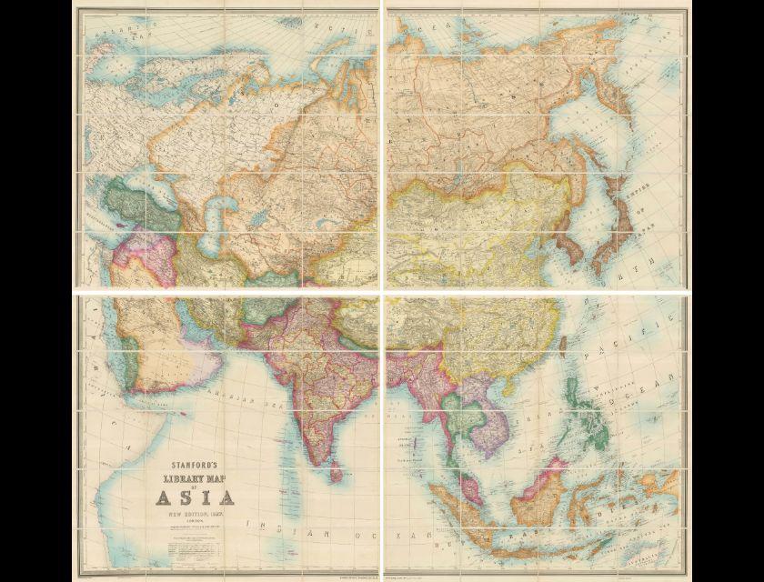
Edward Stanford: Stanford's Library Map of Asia.
Cartographer: Edward Stanford.
Title: Stanford's Library Map of Asia.
Date: 1927.
Published: London.
Monumental folding wall map of Asia showing the political boundaries in 1927. The depiction of India is particularly striking with British territory in pink and native kingdoms in yellow. The Republic of China is at its greatest territorial extent and the Dutch East Indies still covers most of Indonesia.
In the Middle East, the Sykes-Picot line between the British territories (Iraq, Trans-Jordan, and Palestine) and French Syria is clearly demarcated. This stunningly detailed map is one of the finest 20th century wall maps of Asia ever published.
Dimensions
Width: 65 inches / 166 cm, Height: 56 inches / 143 cmStock number
AS1175Open Monday to Friday from 10:00am - 6pm. Saturday from 10:30am - 5pm. Closed Sundays and Bank Holidays.
The BADA Standard
- Since 1918, BADA has been the leading association for the antiques and fine art trade
- Members are elected for their knowledge, integrity and quality of stock
- Our clients are protected by BADA’s code of conduct
- Our dealers’ membership is reviewed and renewed annually
- Bada.org is a non-profit site: clients deal directly with members and they pay no hidden fees