

Price
£1500.00This object is eligible for a Certificate of BADA Provenance
The BADA Standard
- Since 1918, BADA has been the leading association for the antiques and fine art trade
- Members are elected for their knowledge, integrity and quality of stock
- Our clients are protected by BADA’s code of conduct
- Our dealers’ membership is reviewed and renewed annually
- Bada.org is a non-profit site: clients deal directly with members and they pay no hidden fees
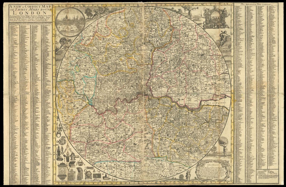
Willdey's rare map of the environs of London.
Title A New & Correct Map of Thirty Miles Round London Shewing all the Towns, Villages, Roads &c with the Seats of the Nobility & Gentry & whatever else is remarkable: Done from the Best Surveys Together with an Alphabetical Table for the ready find of all the Places contain'd in the Map.
Author WILLDEY, George.
Publisher Sold by G. Willdey at ye Corner House in Ludgate Street next St. Pauls.
Publication place London.
Publication date circa 1720.
Engraved circular map, on two sheets joined, hand-coloured in outline, table of place names to left and right of map, mounted on new linen, some minor loss to old folds, trimmed to upper and lower neatlines.
Notes
The map extends from Wokingham in the west to Rochford in the east, and from Stevenage in the north to Horsham in the south. the map bears grid lines for ease of reference, and a key to the bottom right gives details of towns, market towns, parish churches, gentlemen's houses, castles, windmills, watermills, villages, and hamlets.
Surround the map are vignette view of London, upper left, London's commerce, upper right; depictions of Ceres, Hercules, a river god (probably the Thames), a winged messenger (most likely Mercury), and Atlas beard the world on his shoulders. Below the map are the goods available at Willdey's shop together with an advertisement, offering reasonably priced prints and maps.
George Willdey (fl.1707-1737) had broad commercial interests; his shop was stocked with all manner of goods and commodities, many of which are listed and illustrated on this map, including snuff, clocks, globes, wallets, lanterns, a camera obscura, and many scientific instruments. However, the cartographic side of his business seems not to have been very successful, and few examples of his maps survive.
Bibliography
Howgego 69 (1).
Dimensions
670 by 1020mm. (26.5 by 40.25 inches)Stock number
1856The BADA Standard
- Since 1918, BADA has been the leading association for the antiques and fine art trade
- Members are elected for their knowledge, integrity and quality of stock
- Our clients are protected by BADA’s code of conduct
- Our dealers’ membership is reviewed and renewed annually
- Bada.org is a non-profit site: clients deal directly with members and they pay no hidden fees


