

Price
£1600.00This object is eligible for a Certificate of BADA Provenance
The BADA Standard
- Since 1918, BADA has been the leading association for the antiques and fine art trade
- Members are elected for their knowledge, integrity and quality of stock
- Our clients are protected by BADA’s code of conduct
- Our dealers’ membership is reviewed and renewed annually
- Bada.org is a non-profit site: clients deal directly with members and they pay no hidden fees
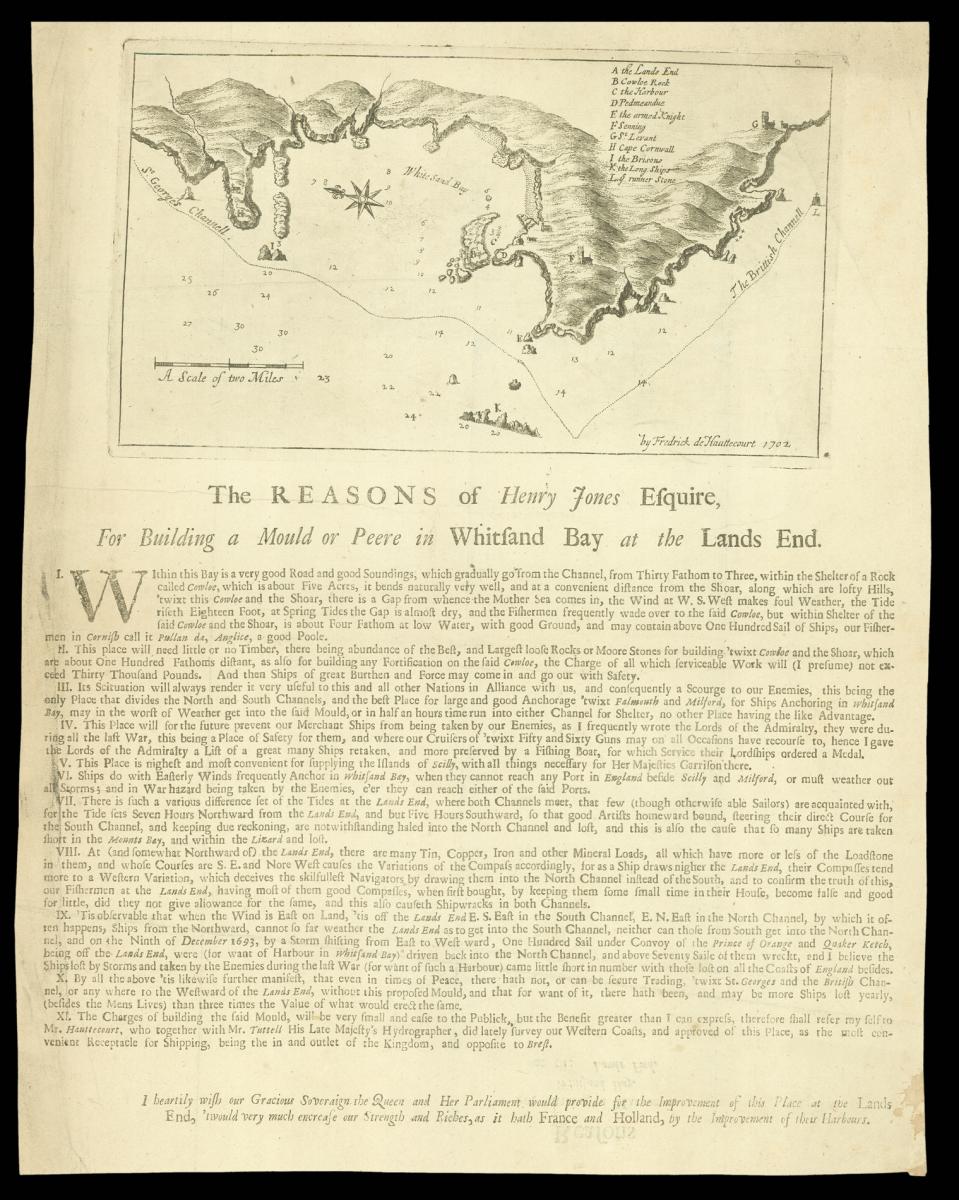
White Sand Bay Cornwall.
Title Untitled Chart of 'White Sand Bay', Cornwall.
Author HAUTTECOURT, Frederick de.
Publisher Henry Jones.
Publication place London.
Publication date circa 1702.
Engraved map.
Notes
Little is known of the surveyor, Frederick de Hauttecourt; his will, dated 16th March, 1704 describes him as "Frederick de Hauttecourt, Gentleman of Saint Margaret Westminster"; he is referred in the text as surveying Cornwall with Thomas Tuttell, the King's Hydrographer, a globe-maker and instrument-maker. The surveys in Cornwall form all his recorded survey work.
The sheet contains a chart of Whitesand Bay set above an extensive letterpress text; the chart shows the Bay, on the tip of Cornwall, from 'H' ('Cape Cornwall'), and the coast just to the north, south to 'G' (S.t Levant'), with the 'K' ('the Long ships') to the coast, surveyed at an approximate scale of one inch to one statute mile. The land was owned by Henry Jones, the presumed publisher, but was later acquired by Edward Boscawen, a vice-admiral in the Navy.
The text notes:
"... The Charges of building the said Mould, will be very small and easie to the Publick, but the Benefit greater than I can express, therefore shall refer my self to Mr. Hauttecourt, who together with Mr. Tuttell His Late Majesty's Hydrographer, did lately survey our Western Coasts, and approved of this Place, as the most convenient Receptacle for Shipping, being the in and outlet of the Kingdom, and opposite to Brest. I heartily wish our Gracious Soveraign the Queen and Her Parliament would provide for the Improvement of this Place at the Lands End, 'twould very much increase our Strength and Riches, as it hath France and Holland, by the Improvement of their Harbours." with particular advantages for Liverpool merchants, whose ships could safely over-night there on the way to and from London, rather than risking the treacherous waters round the Scilly Isles or swinging wide out into the Channel and risking capture by the French.
Bibliography
ESTC T63641: recording four institutional locations: BL, 816.m.8.(74.); Bodleian Library, Pamph. 246(6).; Guildhall Library, Broadsides 4.18.; Yale University, Beinecke Library,1988 74; Hanson, Contemporary printed sources for British and Irish economic history, 1701-1750, 605.
Dimensions
143 by 257mm. (5.75 by 10 inches)Stock number
11347The BADA Standard
- Since 1918, BADA has been the leading association for the antiques and fine art trade
- Members are elected for their knowledge, integrity and quality of stock
- Our clients are protected by BADA’s code of conduct
- Our dealers’ membership is reviewed and renewed annually
- Bada.org is a non-profit site: clients deal directly with members and they pay no hidden fees


