

Price
£1500.00This object is eligible for a Certificate of BADA Provenance
The BADA Standard
- Since 1918, BADA has been the leading association for the antiques and fine art trade
- Members are elected for their knowledge, integrity and quality of stock
- Our clients are protected by BADA’s code of conduct
- Our dealers’ membership is reviewed and renewed annually
- Bada.org is a non-profit site: clients deal directly with members and they pay no hidden fees
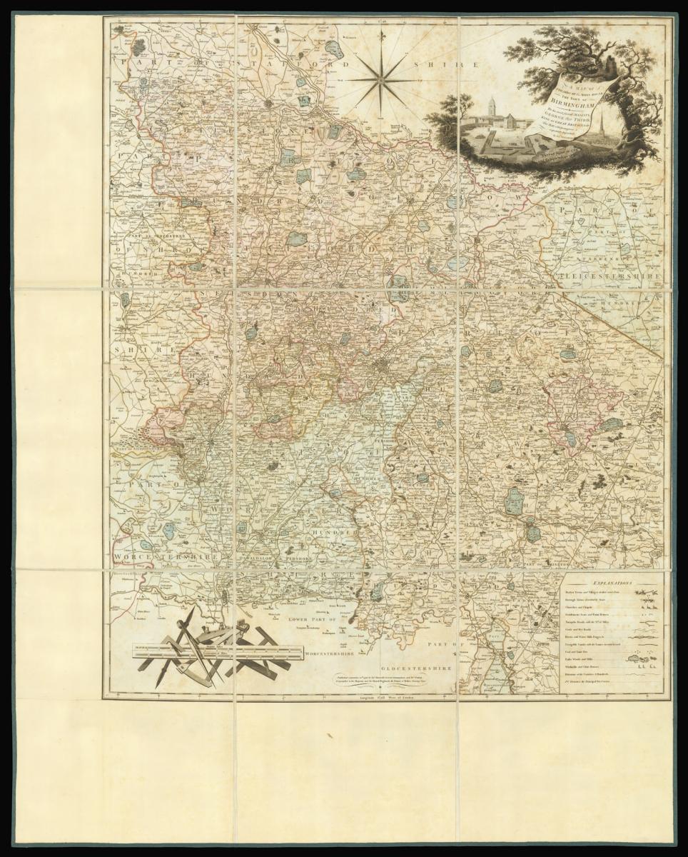
Title [Warwick] A Map of Upwards of 25 Miles round the town of Birmingham To his most sacred Majesty, George the Third, King of Great Britain &c &c. This Map with permission is respectfully Inscribed by James Sherriff. Survey begun in 1788 and completed in 1796.
Author SHERRIFF, James.
Publisher Published by James Sherriff, Cresent Birmingham and W. Faden Geographer to his Majesty and his Royal Highness the Prince of Wales, Charing Cross.
Publication place London.
Publication date September 20th, 1798.
Engraved map on six sheets, dissected and mounted on linen, fine original full wash colour, additional margin to left and lower border, edged in green silk, housed in modern red marbled paper slipcase, with facsimile label.
Notes
The surveyor was carried out by James Sherriff, who states in the title that the work took him eight years to complete (1788-1796), with the work being published in 1798. Sherriff had premises in New Street, Birmingham; he would later go on to produce surveys of the environs of Liverpool in 1800 and 1823. In 1812, he is mentioned in Wrightson's trade directory as a 'surveyor and British winemaker'.
To the upper right of the map is a decorative title cartouche depicting a view of Birmingham. A panel at the bottom right hand corner gives the usual "Explanation" which includes towns and villages, churches and chapels, gentleman's seats and farm houses, turnpike roads with numbers of miles, cross and bye roads, rivers and watermills and navigable canals, coal an lime pits, parks, woods and hils, wind mills and glass houses, divisions of the counties and hundreds plus the principal fox covers.
The work was engraved by Benjamin Baker a prolific producer of engraved maps from the late 18th century onwards. As a map engraver and publisher he resided first at 32 High Street, Islington from 1791 - 1793 and then in Lower Street, Islington from 1798-1800. In 1804 he became principal engraver to the Ordnance Survey and he and his firm were regarded as "the best topographical engravers in Europe."
Dimensions
(image) 845 by 710mm. (33.25 by 28 inches). (with margins) 1030 by 820mm (40.5 by 32.25 inches).Stock number
12794The BADA Standard
- Since 1918, BADA has been the leading association for the antiques and fine art trade
- Members are elected for their knowledge, integrity and quality of stock
- Our clients are protected by BADA’s code of conduct
- Our dealers’ membership is reviewed and renewed annually
- Bada.org is a non-profit site: clients deal directly with members and they pay no hidden fees


