

Sold
This object is eligible for a Certificate of BADA Provenance
The BADA Standard
- Since 1918, BADA has been the leading association for the antiques and fine art trade
- Members are elected for their knowledge, integrity and quality of stock
- Our clients are protected by BADA’s code of conduct
- Our dealers’ membership is reviewed and renewed annually
- Bada.org is a non-profit site: clients deal directly with members and they pay no hidden fees
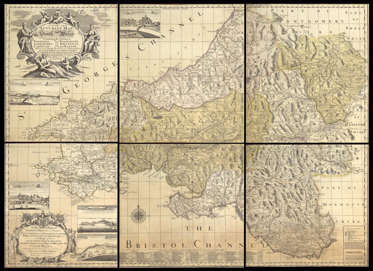
One of the rarest maps of Wales.
Title A New and Accurate Map of South Wales Containing the the Counties of Pembroke, Carmarthen, Cardigan, Glamorgan, Brecknock, and Radnor... by Eman. Bowen.
Author BOWEN, Emanuel.
Publisher Printed for Carington Bowles, in St. Paul's Church Yard, and Robert Sayer No. 53 Fleet Street.
Publication place London.
Publication date circa 1766.
Engraved map on six sheets, original hand colour, trimmed to image, all sheets backed on japan paper, later half calf over red buckram boards.
Notes
Whilst almost every English county was the subject of a large-scale survey in the eighteenth century, this did not apply to Wales, many counties relying on this map of South Wales and Evans' survey of North Wales to provide the detail missing from the maps to be found in the county atlases of the period.
Emanuel Bowen was a prolific engraver and map publisher during the first half of the eighteenth century and was appointed engraver of maps to George II of England and Louis XV of France. He produced several county atlases, in some of which he was assisted by his son Thomas. Despite this commercial success ill-health and impecuniosity dogged both father and son, the later dying in Clerkenwell Workhouse.
Emanuel Bowen's map of the six counties of South Wales detailed, informative and decorative - a splendid example of the mapmaker's art. There are two large cartouches, one giving the title, the other dedicating the map to the Prince of Wales, whilst there are topographical views of Carmarthen, Brecon, Haverfordwest, Tenby and Swansea.
A note on the "Explanation" refers to the "Table of Principal roads" on the bottom of the map which lists over 150 different routes in computed and measured miles. Although this is usually indicated on the map itself, the author tells us that in this instance he considers it provides greater clarity if the information is put on a single table.
The present example is the second edition of the map, which was first published in 1729. Both editions are extremely scare. Roger lists only five institutional examples, and we are able to trace another example appearing at auction in the last 40 years.
Bibliography
Roger 562.
Dimensions
If joined: 1130 by 1580mm (44.5 by 62.25 inches).Stock number
11570The BADA Standard
- Since 1918, BADA has been the leading association for the antiques and fine art trade
- Members are elected for their knowledge, integrity and quality of stock
- Our clients are protected by BADA’s code of conduct
- Our dealers’ membership is reviewed and renewed annually
- Bada.org is a non-profit site: clients deal directly with members and they pay no hidden fees


