Price on application
This object is eligible for a Certificate of BADA Provenance
The BADA Standard
- Since 1918, BADA has been the leading association for the antiques and fine art trade
- Members are elected for their knowledge, integrity and quality of stock
- Our clients are protected by BADA’s code of conduct
- Our dealers’ membership is reviewed and renewed annually
- Bada.org is a non-profit site: clients deal directly with members and they pay no hidden fees
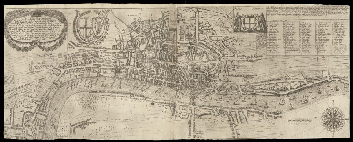
Thomas Porter's exceptionally rare plan of London.
Title The Newest and Exactest Mapp of the most Famous Citties London and Westminster with their Suburbs; and the manner of their Streets: With the Names of the Chiefest of them Written at Length and Numbers set in the rest in sted of Names The which Names are at Length in the Table with Numbers how to Guide them Readily So that it is a ready Helpe or Guide to direct Countrey-men and strangers to finde the nearest way frome one place to another. by T. Porter.
Author PORTER, Thomas.
Publisher Printed & sould by Robt. Walton at the Rose & Crowne at the West end of St. Paules.
Publication place London.
Publication date circa 1655.
Engraved plan printed on two sheets joined, trimmed to neatline.
Notes
The map is probably based upon a copy of the 'Ryther' map, now in the Bodleian Library, which has an extension - in pen and ink - westwards to Pall Mall and Lambeth House. The omission of the Stuart's royal coat-of-arms would suggest that the map was printed at some point in the 1650s.
Howgego suggests a date of 1655, as the imprint upon the map is the same as present in Thomas Porter's 'New Book of Maps...' published in 1655. To the upper left is the long title, set within an elaborate title cartouche. In the title, the wish is expressed that the map "is a ready helpe or Guide to direct Countrey-men and Strangers to finde the nearest way from one place to another".
To the right are the St George's Cross, the Harp of Ireland, and the Cross of St. Andrew. Further right, the City's arms are flanked by personifications of Justice and Prudence, and a list important "Streets, Places, Hills, Lanes, and Allies (sic) which for want of room could not be written".
To the lower right is an elaborate compass rose and scale bar. The plan itself is finely engraved and shows Westminster and Lambeth House (Lambeth Palace) in the west to Lyme-House (sic) in the east, Pall Mall is written 'Pell Mell', and the grand houses and wharves along the Thames are named. Upon the Thames, ferrymen, barges and sailing vessels are shown.
Only two other examples of the map are known: the one in the British Library's Crace Collection (Crace 34), differs from the present copy by the naming of 'Bowe Street' in Westminster.
Upon the present plan the street is named 'Theeving Lane', which was the street's earlier name; therefore the present copy predates the Crace copy. The other example, housed at the Society of Antiquaries, is an even later state, and bears the royal coat-of-arms. It was later reproduced in facsimile by the London Topographical Society in 1898.
Scale: approx. 6 inches to 1 statute mile.
Bibliography
Howgego 11 (1).
Dimensions
290 by 760mm (11.5 by 30 inches)Stock number
1503The BADA Standard
- Since 1918, BADA has been the leading association for the antiques and fine art trade
- Members are elected for their knowledge, integrity and quality of stock
- Our clients are protected by BADA’s code of conduct
- Our dealers’ membership is reviewed and renewed annually
- Bada.org is a non-profit site: clients deal directly with members and they pay no hidden fees