

Price
£1500.00This object is eligible for a Certificate of BADA Provenance
The BADA Standard
- Since 1918, BADA has been the leading association for the antiques and fine art trade
- Members are elected for their knowledge, integrity and quality of stock
- Our clients are protected by BADA’s code of conduct
- Our dealers’ membership is reviewed and renewed annually
- Bada.org is a non-profit site: clients deal directly with members and they pay no hidden fees
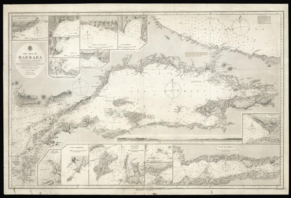
The Sea of Marmara with Istanbul and the Bosphorus.
Title The Sea of Marmara from surveys by Captn Manganari Russian Navy 1845, 48 and Captain Spratt and other Officers of the R.N.
Author MANGANARI, Captain and SPRATT, Captain Thomas Abel Brimage.
Publisher The Admiralty.
Publication place London.
Publication date 1859. Corrections to 1873. Minor corrections to 1877.
Engraved chart, 14 inset views, a few tears to lower margin and image skilfully repaired, some loss to imprint, reapired, old gule marks to verso.
Notes
This rare chart of the Sea of Marmara was made at a critical time in the region's history. The Sea of Marmara, the Black Sea, and the Bosporus and Dardanelles straits are of central importance for the governance of Istanbul, and so the conflicts of the Ottoman Empire often rested on a detailed understanding of the waters.
In the 1840s, joint Ottoman and Russian forces launched an expedition under Captain Manganari to complete the first systematical survey of the Black Sea using triangulation, which "deserves to be counted among the greatest contributions to the cartography of the sea" (King); the results of their work were published as an atlas, which "deserves to be counted among the greatest contributions to the cartography of the sea" (King), ands remained highly influential for over 30 years.
During the Crimean War, however, the British navy became involved in the area, and Captain Thomas Spratt was deployed on the Spitfire to create an accurate chart, noting the positions of the allied fleet for the attack on Sevastopol. Spratt was later appointed to the Order of Bath, and subsequently to the Royal Society for his other geographical work.
His chart of the Sea of Marmara shows depth in soundings and isolines, relief in hachures, and identifies important towns, cities and ports. Notes about lighthouses and beacons provide additional information that would prove useful for both sailors and the military.
Similarly, the 14 inset views on the upper and lower border allow for a more detailed examination of certain significant coastal areas. The imprint in the lower right corner identifies the engraving of this chart as the work of John and Charles Walker. Walker Cartographers had been responsible for naval charts since the British Hydrographic Office was established in the late eighteenth century, and subsequently produced numerous charts of the colonies.
While this map is typical of the nineteenth century naval charts produced by the British Admiralty, it is equally rare, with only two institutional examples - The National Maritime Museum, and the Connecticut State Library.
Bibliography
NMM G236:2/9
Dimensions
650 by 1005mm (25.5 by 39.5 inches)Stock number
14359The BADA Standard
- Since 1918, BADA has been the leading association for the antiques and fine art trade
- Members are elected for their knowledge, integrity and quality of stock
- Our clients are protected by BADA’s code of conduct
- Our dealers’ membership is reviewed and renewed annually
- Bada.org is a non-profit site: clients deal directly with members and they pay no hidden fees


