Price
£445.00This object is eligible for a Certificate of BADA Provenance
The BADA Standard
- Since 1918, BADA has been the leading association for the antiques and fine art trade
- Members are elected for their knowledge, integrity and quality of stock
- Our clients are protected by BADA’s code of conduct
- Our dealers’ membership is reviewed and renewed annually
- Bada.org is a non-profit site: clients deal directly with members and they pay no hidden fees
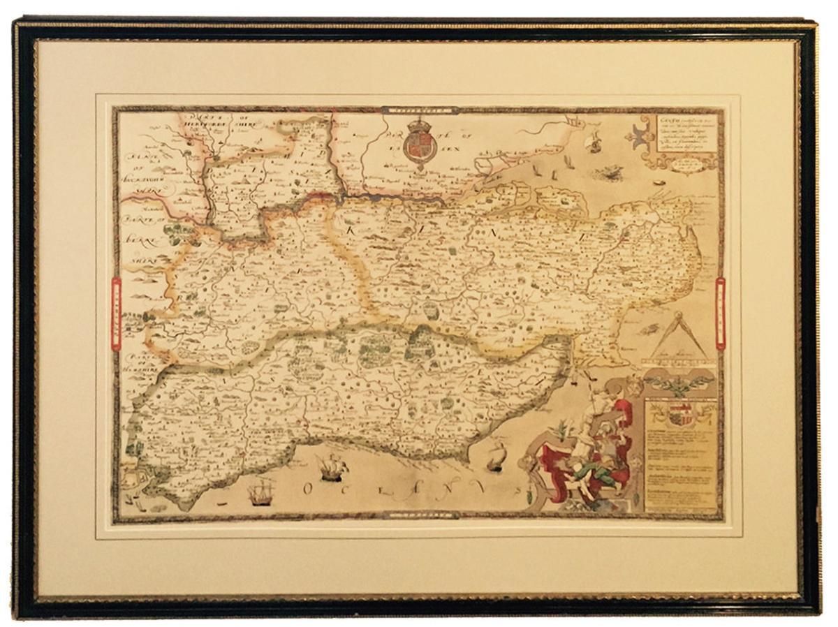
Saxton’s Map of Kent Sussex Surrey and Middlesex 1575.
Inscribed Emery Walker Limited, Collotypers and “British Museum. Maps C.7. c.I.” Published by Emery Walker (1851 - 1933), a map of Kent and the neighbouring counties, originally from the 1583 edition of the Saxton atlas of England and Wales, which was first published as a whole in 1579. Map bears date inscription top right ‘Anno Dom 1575 et D. Elizabethe Regine A 19’ and engraver’s name Remigius Hogenberg in the scale bar. Bears royal crest and all script is in Latin.
English, circa 1900 - 1930.
W. 28 ¼” (72cm).
H. 22 ¾” (58cm).
Information from the British Library.
This map of Kent and the neighbouring counties of Sussex, Middlesex and Surrey is from the 1583 edition of the Saxton atlas of England and Wales. This atlas was first published as a whole in 1579. It consists of 35 coloured maps depicting the counties of England and Wales. The atlas is of great significance to British cartography as it set a standard of cartographic representation in Britain and the maps remained the basis for English county mapping, with few exceptions, until after 1750. During the reign of Elizabeth I map use became more common, with many government matters referring to increasingly accurate maps with consistent scales and symbols, made possible by advances in surveying techniques. Illustrating the increasing used of maps in government matters, Lord Burghley, Elizabeth I’s Secretary of State, who had been determined to have England and Wales mapped in detail from the 1550s, selected the cartographer Christopher Saxton to produce a detailed and consistent survey of the country. The financier of the project was Thomas Seckford Master of Requests at the Court of Elizabeth I, whose arms appear, along with the royal crest, on each map. In the bottom right corner a scale bar and a written description of the counties and of London. Although at a small scale London is shown in some detail in the map with St Paul’s Cathedral and London bridge clearly discernable. St Paul’s is correctly shown without its steeple which was destroyed by lightning in 1561 and was not replaced. Paddington Highgate and Camberwell are shown as outlying countryside, as yet un colonised by the metropolis. In neighbouring Berkshire Windsor is marked by a larger group of red structures than its neighbours, reflecting the royal association with Windsor and the presence of the castle, the park is also shown as a large wooded enclosure. Hampton Court is also marked. The name of the engraver Remigius Hogenberg, one of seven English and Flemish engravers employed to produced the copper plates for the atlas, is contained in the scale bar.
Stock number
1558Open Monday - Saturdays 10am - 5pm and by appointment. Closed Bank Holidays
The BADA Standard
- Since 1918, BADA has been the leading association for the antiques and fine art trade
- Members are elected for their knowledge, integrity and quality of stock
- Our clients are protected by BADA’s code of conduct
- Our dealers’ membership is reviewed and renewed annually
- Bada.org is a non-profit site: clients deal directly with members and they pay no hidden fees