

Price on application
This object is eligible for a Certificate of BADA Provenance
The BADA Standard
- Since 1918, BADA has been the leading association for the antiques and fine art trade
- Members are elected for their knowledge, integrity and quality of stock
- Our clients are protected by BADA’s code of conduct
- Our dealers’ membership is reviewed and renewed annually
- Bada.org is a non-profit site: clients deal directly with members and they pay no hidden fees
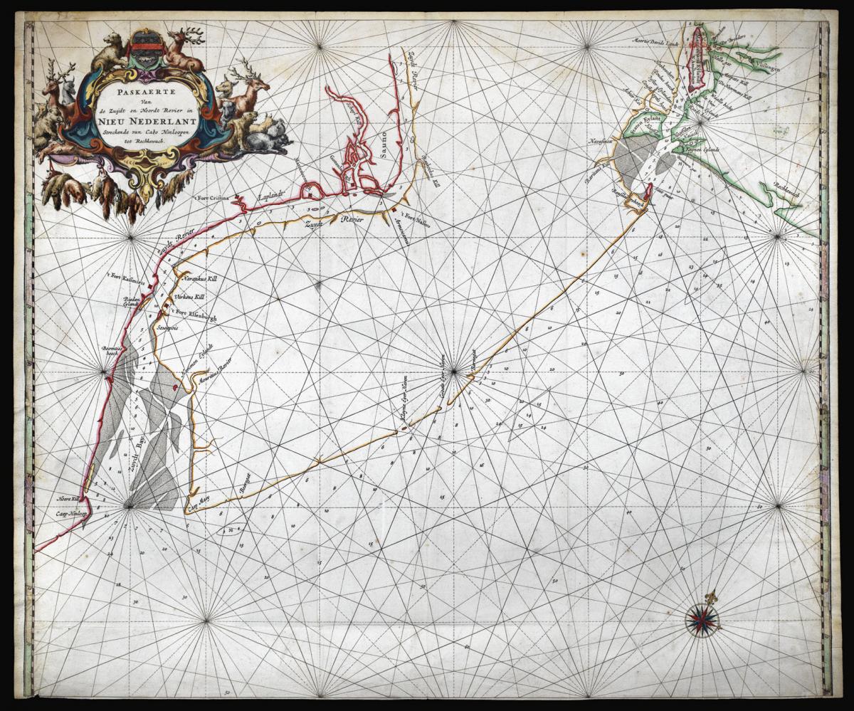
The rarest of the Goos charts of North America.
Title Paskaerte Van de Zuydt en Noordt Revier in Nieu Nederlant, Streckende van Cabo Hinloopen tot Rechlewach.
Author GOOS, Pieter.
Publisher Pieter Goos.
Publication place Amsterdam.
Publication date 1666.
Double-page engraved map, with fine hand-colour in full, heightened in gold.
Notes
The first map of present-day New Jersey, and the most detailed map of the region of New Amsterdam, or New York, to date.
Probably first published separately and possibly before 'De Zee Atlas ofte Water-Weereld', as it is larger than the other charts in the atlas. It may also have been included upon request, as it is not often listed in the index. Burden describes it as the rarest of the Goos charts of America.
The chart is centered on what "was the lower half of the New Netherlands, which was made up of two distinct colonies, New Amsterdam under the control of the Dutch West India Company, and Nieuwer Amstel on the Delaware River. In 1638, the Swedish colony of 't Fort Cristina' was built by Peter Minuit, the same person who had 'bought' Manhattan Island for the Dutch from the Indians over a decade earlier. Although this was not far from the Dutch fort of Nassou they lived harmoniusly together.
Later the Swedish built two more forts, 't Fort Elsenburgh' down river in 1642, and 'Gottenburgh' closer to Fort Nassau in the following year. The Dutch under Peter Stuyvesant responded by building 't Fort Kasimiris opposite Fort Elsenbugh in 1651. This was captured by the Swedes in 1654. The following year the Dutch captured the entire Swedish colony.
The area of Fort Christina was sold by the company to the city of Amsterdam in 1656. They founded the colony of Nieuwer Amstel, which fell to the English in 1664. Interestingly, the coat-of-arms in the cartouche is that of this small colony, and, if the beaver is removed, it matches that of the town of the same name near Amsterdam" (Burden).
There is only one known state of the map. However, the plate was by Joannes van Keulen in 1681, who, in a fit of economy, erased the map and replaced it with one of the Baltic Sea, for his 'Zee-Fakkel'. He preserved the tell-tale cartouche depicting animals of the fur trade.
Pieter Goos (1616-1675) was one of the most important of the booksellers in Amsterdam during the second half of the seventeenth-century. His first pilot book was the Zee-Spiegel, 1650, covering largely European waters. The Zee Atlas covered the whole world. Goos's atlases and pilots were designed for the armchair traveler rather than as navigational aids: Goos's prospective clients were "Heeren en Kooplieden" (gentleman and merchants) before "Schippers en Stuurlieden" (pilots and seamen). This land-based market improved the atlas' survival rate over others of the period.
Bibliography
Burden 388
Dimensions
510 by 610mm (20 by 24 inches).Stock number
14337The BADA Standard
- Since 1918, BADA has been the leading association for the antiques and fine art trade
- Members are elected for their knowledge, integrity and quality of stock
- Our clients are protected by BADA’s code of conduct
- Our dealers’ membership is reviewed and renewed annually
- Bada.org is a non-profit site: clients deal directly with members and they pay no hidden fees


