Price on application
This object is eligible for a Certificate of BADA Provenance
The BADA Standard
- Since 1918, BADA has been the leading association for the antiques and fine art trade
- Members are elected for their knowledge, integrity and quality of stock
- Our clients are protected by BADA’s code of conduct
- Our dealers’ membership is reviewed and renewed annually
- Bada.org is a non-profit site: clients deal directly with members and they pay no hidden fees
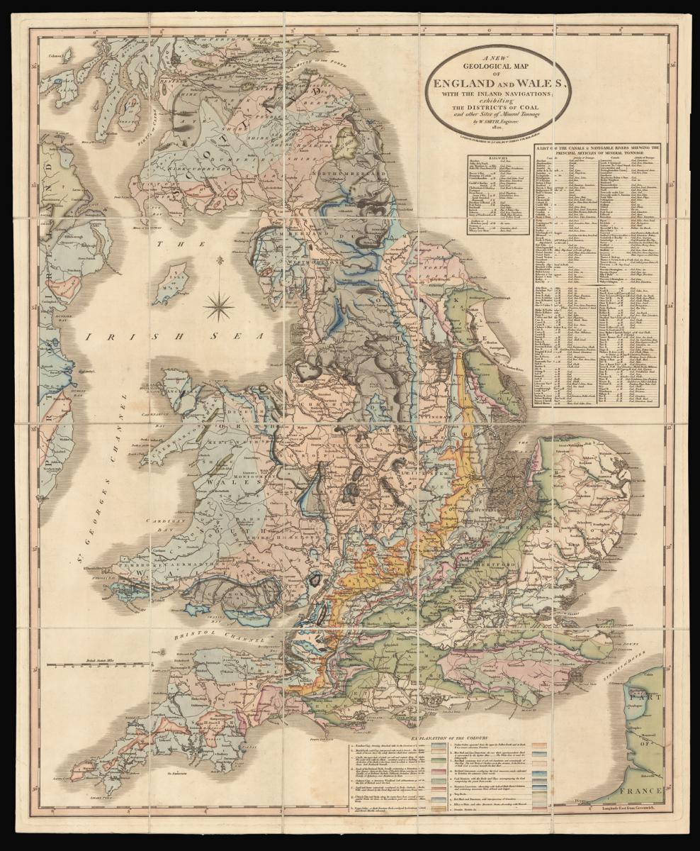
Rare reduction of William Smith's seminal geological map.
Title A New Geological Map of England and Wales, with the inland navigations; exhibiting the districts of Coal and other Sites of Mineral Tonnage by W. Smith, Engineer: 1820.
Author SMITH, William.
Publisher Published by J. Cary, 86 St James's Str.
Publication place London.
Publication date March 18th, 1820.
Engraved map, fine original hand colour, dissected and mounted on linen, two small stains near the Thames Estuary, folding into original green marbled paper slipcase, publisher's label pasted to upper board, rubbed.
Notes:
Rare reduction of William Smith's seminal geological map; the first large scale, detailed scientific geological map of any country.
The map, described on the slipcase label as "reduced from Smith's large map:' incorporates all of Smith's many revisions to his original geological map of 1815, including changes made subsequent to the latest issue (post-1817) of the wall-map. "Copies have been recorded dated 1824, 1827, and 1828, but no change in the geological lines has been observed, although the shades of colour may vary" (Eyles).
The present single-sheet map was published during the same period as Smith's "Geological Survey Atlas of England:' a series of 24 slightly smaller county maps coloured to show geological strata, issued in parts of 3 maps each from 1819 through 1824.
Smith may have planned to sell the general map of England along with the completed series, however, due to lack of funds the atlas project was never completed. The printed title label on the slipcase states that the present map was "intended as an elementary map for those commencing the study of geology".
Rare we are only able to trace ten institutional examples.
Bibliography:
J. Challinor, "The Beginnings of Scientific Palaeontology in Britain" Annals of Science 6 (1948): 46-53; Joan M. Eyles, "William Smith", in Dictionary of Scientific Biography (vol.12), ed. Charles Coulston Gillispie (New York: Scribner, 1970-80) 486-492; Eyles, "William Smith: A Bibliography of his Published Writings, Maps and Geological Sections" Journal of the Society for the Bibliography of Natural History V (1969); H.D. Horblit, One hundred books famous in science: based on an exhibition held at the Grolier Club (New York: Grolier Club, 1964), 94; Ruth A. Sparrow, Milestones of Science: Epochal books in the history of science as represented in the Buffalo Society of Natural Sciences, (Buffalo: Buffalo Society of Natural Sciences, 1972), 180; Simon Winchester, The Map that Changed the World (London: Harper Collins, 2001).
Dimensions
780 by 645mm. (30.75 by 25.5 inches)Stock number
15289The BADA Standard
- Since 1918, BADA has been the leading association for the antiques and fine art trade
- Members are elected for their knowledge, integrity and quality of stock
- Our clients are protected by BADA’s code of conduct
- Our dealers’ membership is reviewed and renewed annually
- Bada.org is a non-profit site: clients deal directly with members and they pay no hidden fees