

Price on application
This object is eligible for a Certificate of BADA Provenance
The BADA Standard
- Since 1918, BADA has been the leading association for the antiques and fine art trade
- Members are elected for their knowledge, integrity and quality of stock
- Our clients are protected by BADA’s code of conduct
- Our dealers’ membership is reviewed and renewed annually
- Bada.org is a non-profit site: clients deal directly with members and they pay no hidden fees
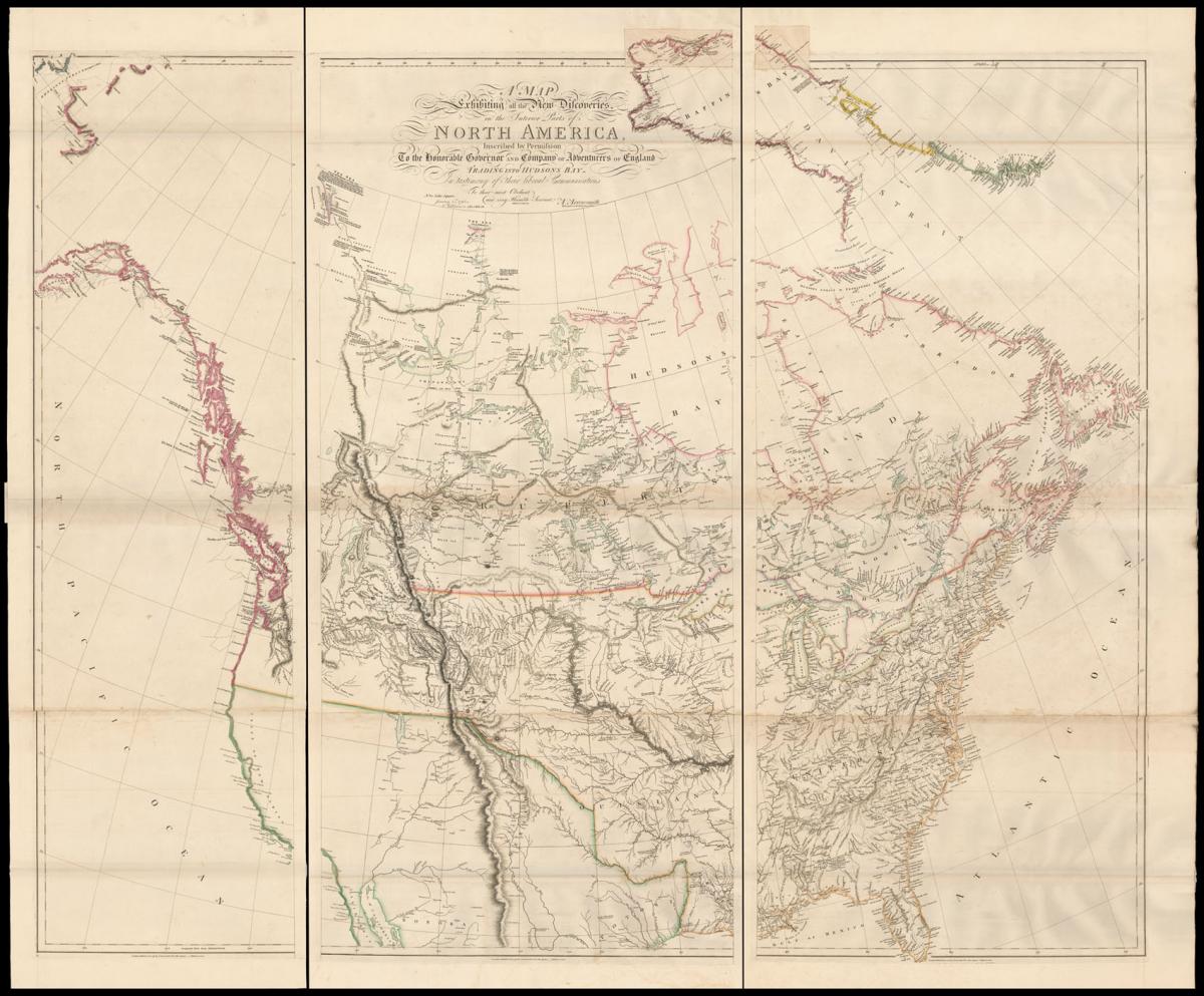
One of the most important maps of the American West.
Title A Map Exhibiting all the New Discoveries in the Interior Parts of North America, Inscribed by Permission To the Honorable Governor and Company of Adventurers of England Trading into Hudson Bay. In testimony of their liberal Communications. To their most Obedient and very Humble Servant A. Arrowsmith.
Author ARROWSMITH, Aaron.
Publisher Published by A. Arrowsmith, No.10 Soho Square.
Publication place London.
Publication date 1st January 1795, but 1819.
Large engraved map, on six sheets joined as three, fine original outline hand-colour, paste over extension sheet to upper margin.
Notes
A landmark map in the charting of the American West.
Arrowsmith first published his map in 1795 and by constantly issuing updated versions, as new information became available, he ensured that the map retained its reputation as the best general map for the American West.
It was the 1802 edition that was used by Lewis & Clark to plan their own expedition of 1805-06; and the map's 1814 edition is justlty famed as the first large scale map to incorporate their discoveries.
It has been noted that the map is a great deal more accurate than the one published to accompany the first edition of Lewis & Clark's travels.
This is due to Arrowsmith drawing on numerous sources most notably from new information from the British explorer David Thompson - whose information helped greatly with the delineation of the Columbia river - and that of the Hudson Bay Company.
The map also extends some way south to include the Gulf of Mexico; the information of which was taken from the works of Zebulon Pike and Humboldt.
The revisions would continue with the present 1819 edition of the map drawing on the latest American maps including those of Darby and Melish.
Bibliography
Rumsey 32 ; Stevens & Tree, 'Comparative Cartography', 48(f), in Tooley, The Mapping of America.
Dimensions
1300 by 1600mm. (51.25 by 63 inches)Stock number
1082The BADA Standard
- Since 1918, BADA has been the leading association for the antiques and fine art trade
- Members are elected for their knowledge, integrity and quality of stock
- Our clients are protected by BADA’s code of conduct
- Our dealers’ membership is reviewed and renewed annually
- Bada.org is a non-profit site: clients deal directly with members and they pay no hidden fees


