Price
£900.00This object is eligible for a Certificate of BADA Provenance
The BADA Standard
- Since 1918, BADA has been the leading association for the antiques and fine art trade
- Members are elected for their knowledge, integrity and quality of stock
- Our clients are protected by BADA’s code of conduct
- Our dealers’ membership is reviewed and renewed annually
- Bada.org is a non-profit site: clients deal directly with members and they pay no hidden fees
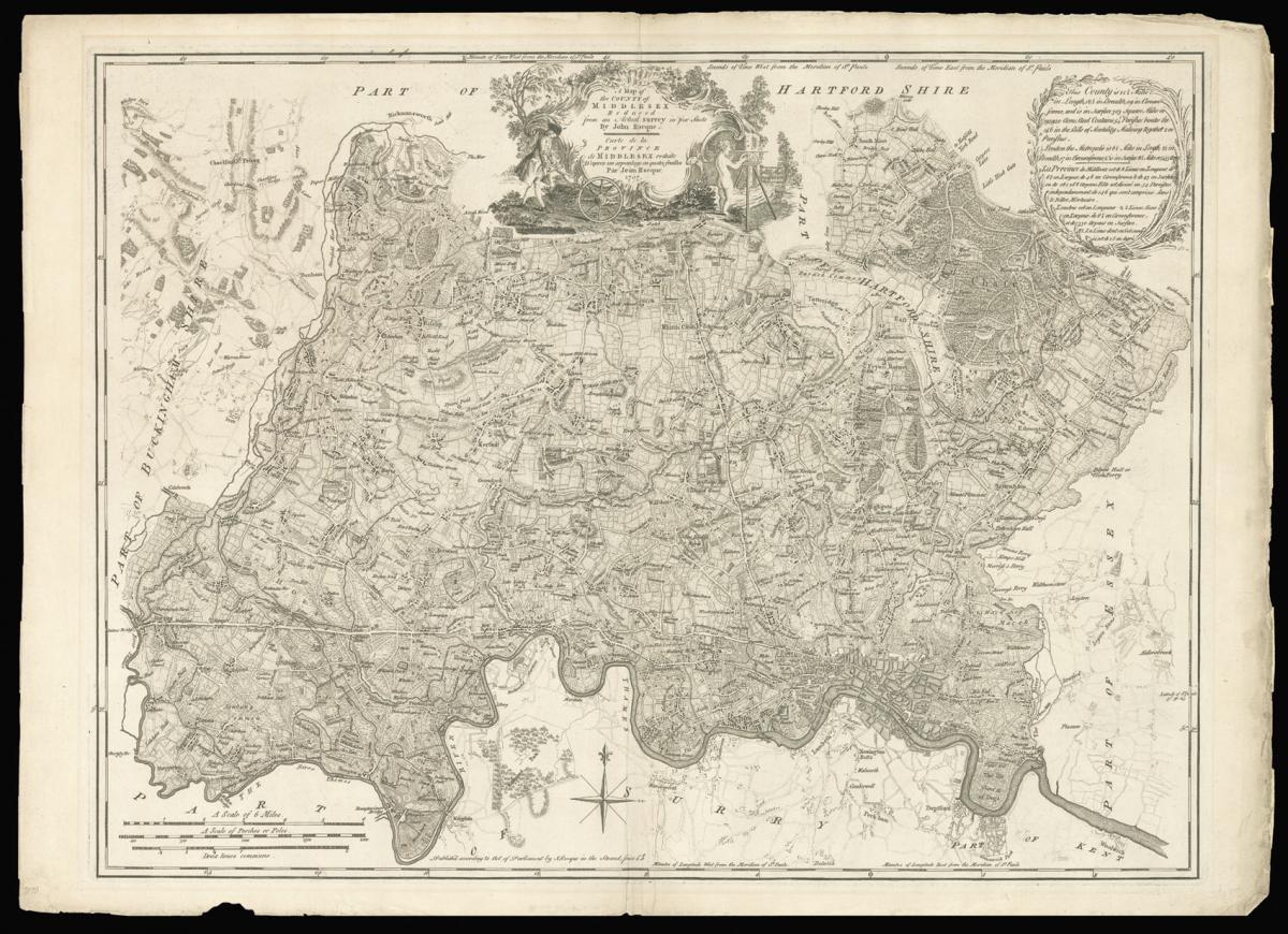
Rocque's fine separately issued map of Middlesex.
Title A Map of the County of Middlesex Reduced from the an Actual Survey in four Sheets By John Rocque. Carte de la Province de Middlesex reduite D'apres un arpanlage en quatre feuilles Par Jean Rocque 1757. Price 2s 6d.
Author ROCQUE, John.
Publisher according to Act of Parliament by J. Rocque in the Strand.
Publication place London.
Publication date 1757.
Engraved map, minor loss to margins.
Notes
Rocque's finely engraved map of Middlesex.
The map extends from Staines in the west to Leytonstone and from Harefield in the north to Kingston-upon-Thames in the south. To the upper centre is a fine title cartouche with depictions of a Georgian surveyor holding a waywiser, and a putti using a plane.
The text to the upper right gives details on the extent of the county, together with the extent of London, which is said to be 6 and a half miles in length, 2 and a half in breadth, has a circumference of 8 and a half miles or 5455 acres.
It would appear that John Rocque, a French Huguenot, emigrated with the rest of his family to London in the 1730s, where he began to ply his trade as a surveyor of gentleman's estates, and with plans of Kensington Gardens, and Hampton Court.
However, in 1737 he applied his surveying skills to a much greater task, that of surveying the entire built-up area of London - a survey that would make his name. Begun in March of 1737, the map would take nine years to produce, eventually being engraved upon 24 sheets of copper and published in 1746.
Bibliography
BL Cartographic Items Maps K.Top.20.8.
Dimensions
515 by 695mm. (20.25 by 27.25 inches)Stock number
2412The BADA Standard
- Since 1918, BADA has been the leading association for the antiques and fine art trade
- Members are elected for their knowledge, integrity and quality of stock
- Our clients are protected by BADA’s code of conduct
- Our dealers’ membership is reviewed and renewed annually
- Bada.org is a non-profit site: clients deal directly with members and they pay no hidden fees