Sold
This object is eligible for a Certificate of BADA Provenance
The BADA Standard
- Since 1918, BADA has been the leading association for the antiques and fine art trade
- Members are elected for their knowledge, integrity and quality of stock
- Our clients are protected by BADA’s code of conduct
- Our dealers’ membership is reviewed and renewed annually
- Bada.org is a non-profit site: clients deal directly with members and they pay no hidden fees
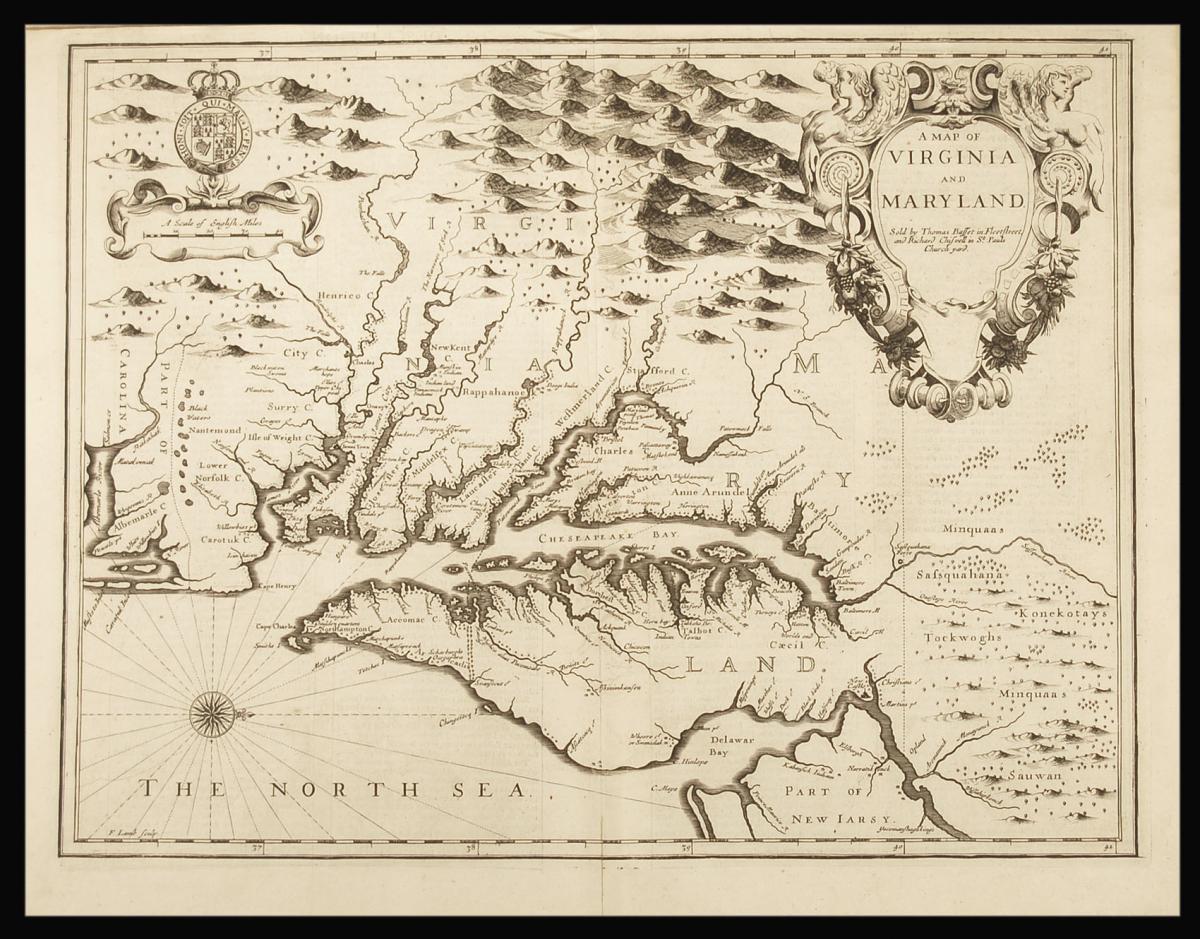
Maryland and Virginia.
Title A Map of Virginia and Maryland.
Author SPEED, John & LAMB, Francis.
Publisher Thomas Bassett.
Publication place London.
Publication date 1676.
Engraved map (380 by 510mm to the neatline, full margins, showing the plate mark), text on verso.
Notes
A fine and attractive map of Virginia and Maryland.
Publishers Thomas Bassett and Richard Chiswell republished English cartographer John Speed's (1552-1629) popular 1611 atlas, "The Theatre of the Empire of Great Britain," in 1676. As a supplement, they included new section, "A Prospect of the most Famous parts of the World," which contained maps of the English colonies of New England, Virginia, and Maryland.
The Maryland and Virginia map was the ninth (and last) derived from John Smith's 1612 map of the region. Smith's map was widely copied and remained the most accurate map of the Chesapeake until Augustine Herrman's 1673 representation of the region. The text on the verso is condensed from John Ogilby's "America".
Francis Lamb's original work combined two earlier maps. He retained Smith's original orientation (West is at the top—offering the land from the perspective of a ship sailing from England) and incorporated Hermann's geographical details into his own. This map has been repeatedly, and incorrectly, attributed to Speed because it first appeared in the major re-publication of his earlier work. By 1676, Speed had been dead for 47 years.
Bibliography
"Virginia, Discovered and Described: John Smith's Map of Virginia and Its Derivatives,"
The Library of Virginia, http://www.lva.virginia.gov/public/guides/rn28_johnsmith.pdf.
"A Map of Virginia and Maryland," New York Public Library.
Dimensions
170 by 540mm. (6.75 by 21.25 inches)Stock number
12805The BADA Standard
- Since 1918, BADA has been the leading association for the antiques and fine art trade
- Members are elected for their knowledge, integrity and quality of stock
- Our clients are protected by BADA’s code of conduct
- Our dealers’ membership is reviewed and renewed annually
- Bada.org is a non-profit site: clients deal directly with members and they pay no hidden fees