Price on application
This object is eligible for a Certificate of BADA Provenance
The BADA Standard
- Since 1918, BADA has been the leading association for the antiques and fine art trade
- Members are elected for their knowledge, integrity and quality of stock
- Our clients are protected by BADA’s code of conduct
- Our dealers’ membership is reviewed and renewed annually
- Bada.org is a non-profit site: clients deal directly with members and they pay no hidden fees
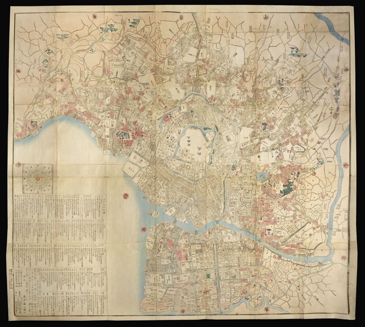
Map of Edo.
Title O-Edo ōezu/Takai Ranzan zu.
Author TAKAI, Ranzan.
Publisher Go-shomotsushi Izumoji Manjirō: Okadaya Kashichi.
Publication place Edo.
Publication date 1859.
Woodblock printed map of Edo, north oriented to the right.
Notes
A large detailed cadastral map of Edo [Tokyo], showing landowners, main temples and shrines and other points of interest depicted pictorially in relief.
During the end of the Edo Period, Rangaku, or "Dutch Learning," dominated Japanese art and science. This map exemplifies the union of Japanese traditional printmaking and Dutch cartography. The latter half of the Edo Period is known as the Bakumatsu Era, when traditional feudal authorities resisted the increasing western influence, creating a tense social division. It represents the historical, social and political characteristics of the Bakumatsu era.
At the center of Edo, present-day Tokyo, marks the head of state and the Japanese legal authority. Within the central living quarters, there is a Western circle called nishinomaru. The royal living quarters are surrounded by a group of mansions, called the daimyo-koji, or "warlord ally." The relationship between spatial orientation and hierarchy is very clear, as all of the surrounding structures face the center.
North is oriented to the right.
Insets: 江戶方角道法 Edo hōgaku dōhō (distance chart), 江戶年中行事 Edo nenju gyōji (list of daily events for Edo).
First printed Genroku 9 [1696], later revised Bunsei 5 [1822], reprinted Tenpō 14 [1843], and current edition Ansei 6 [1859].
Bibliography
Beans, A List of Japanese Maps of the Tokugawa Era I, 39.
Dimensions
1210 by 1340mm. (47.75 by 52.75 inches)The BADA Standard
- Since 1918, BADA has been the leading association for the antiques and fine art trade
- Members are elected for their knowledge, integrity and quality of stock
- Our clients are protected by BADA’s code of conduct
- Our dealers’ membership is reviewed and renewed annually
- Bada.org is a non-profit site: clients deal directly with members and they pay no hidden fees