Price on application
This object is eligible for a Certificate of BADA Provenance
The BADA Standard
- Since 1918, BADA has been the leading association for the antiques and fine art trade
- Members are elected for their knowledge, integrity and quality of stock
- Our clients are protected by BADA’s code of conduct
- Our dealers’ membership is reviewed and renewed annually
- Bada.org is a non-profit site: clients deal directly with members and they pay no hidden fees
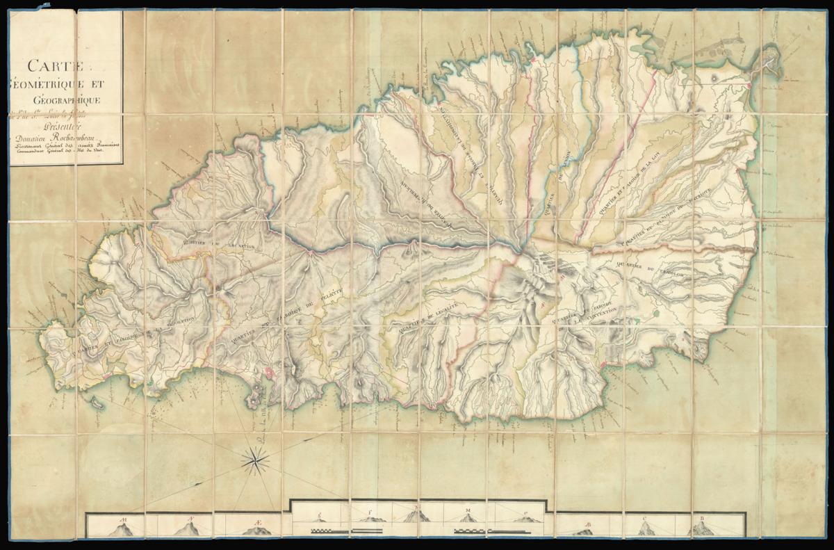
Large manuscript map of St Lucia from the library of Donatien-Marie-Joseph de Vimeur, vicomte de Rochambeau.
Title Carte géométrique et géographique de l'île de Sainte-Lucie La Fidèle présentée par Donatien Rochambeau [Geometric and geographic map of the island of St Lucia the Faithful presented by Donatien Rochambeau]
Author ROCHAMBEAU, Donatien-Marie-Joseph de Vimeur, vicomte de
Publication date 1792-1794
Manuscript watercolour map, dissected and mounted on linen, manuscript library inscription to verso.
Notes
In 1792, the National Assembly appointed Rochambeau Lieutenant Governor General of the Windward Isles, including the islands of St. Lucia, Guadeloupe and Martinique.
Rochambeau was unable to land in Martinique for four months after his arrival, facing cannon fire from royalist sympathisers. Although he finally took up his post in January 1793, the island was promptly besieged by the British twice in the following six months.
The British were assisted by white planters in Martinique who did not want black inhabitants of the island to be given French citizenship, as decreed by the Convention back in Paris. Unlike Martinique, the people of St Lucia remained loyal to the revolutionary government, which is why the island was given the name Sainte-Lucie La Fidèle - "Saint Lucia the Faithful".
Rochambeau presumably either drew or commissioned the map either while in Dominica, waiting to take up his post as governor, or before the British attacked Martinique. It focuses on maritime navigation around the island, giving the names of ports and coves and showing a series of landmarks along the lower edge that could be used to find bearings while at sea.
The island is divided into 11 quarters, as it is today, but they were renamed following the French Revolution in 1789. The names here reflect republican ideals: for example, "Quartier du Tricolor", "Quartier de la Nation" and "Quartier et Paroisse du Patriot".
Provenance
Donatien-Marie-Joseph de Vimeur, vicomte de Rochambeau. From the library of the Rochambeau family.
Dimensions
Dimensions 890 by 1370mm. (35 by 54 inches)Stock number
12535The BADA Standard
- Since 1918, BADA has been the leading association for the antiques and fine art trade
- Members are elected for their knowledge, integrity and quality of stock
- Our clients are protected by BADA’s code of conduct
- Our dealers’ membership is reviewed and renewed annually
- Bada.org is a non-profit site: clients deal directly with members and they pay no hidden fees