Price on application
This object is eligible for a Certificate of BADA Provenance
The BADA Standard
- Since 1918, BADA has been the leading association for the antiques and fine art trade
- Members are elected for their knowledge, integrity and quality of stock
- Our clients are protected by BADA’s code of conduct
- Our dealers’ membership is reviewed and renewed annually
- Bada.org is a non-profit site: clients deal directly with members and they pay no hidden fees
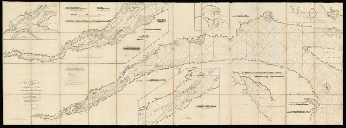
First state of Cook's seminal map of the St Laurence River.
Title A New Chart of the River St Laurence, from the Island of Anticosti To the Falls of Richelieu: With all the islands, rocks, shoals, and soundings, also particular directions for navigating the river with safety.
Taken by Order of Charles Saunders, Esqr. Vice-Admiral of the Blue and Commander in Chief of His Majesty's Ships in the Expedition against Quebec in 1759.
This chart was drawn from particular surveys of the following places; and published for the use of British navigators, by command of the Right Honourable the Lords Commissioners of the Admiralty Charles Saunder, Pall Mall, May 1st., 1760.
Author COOK, Captain James.
Publisher Published by Command of The Right Honourable the Lords Commissioners of the Admiralty.
Publication place London.
Publication date 1760.
Engraved chart in 12 sheets, dissected and laid on linen. Modern marbled paper slipcase, embossed red morocco title label.
Notes
First state of Cook's seminal map of the St Laurence River.
Captain Cook's famous chart. The rare first state of the most important published chart for the river and Gulf of St Lawrence of the eighteenth century.
This remarkable chart, over seven feet long, was so accurate that it "became the standard guide not only for the navy but for all seamen using the great waterway" (Beaglehole).
In preparation for an amphibious attack on Quebec, during the French and Indian War, the British initially relied on captured French charts but, in view of the treacherous nature of stretches of the river, and lack of first-hand knowledge of the river, assembled a distinguished team of military surveyors, notably Samuel Holland, Joseph Frederick Wallet des Barres and, later to eclipse them all, the young James Cook.
Although the impetus for this chart is credited to Charles Saunders, commander of the fleet at Quebec, much of the work was carried out under the auspices of Vice-Admiral Philip Durell, himself a distinguished hydrographer, who was entrusted with the task of keeping British shipping and supplies moving up- and down-river, for which ever more accurate charts were required.
The survey materials were taken back to England by Admiral Saunders and given to the Lords Commissioners of the Admiralty, who passed them to Thomas Jefferys, mapmaker to the British government, for publication. Saunders presented examples to the King and the Prince of Wales in May 1760.
Cook's extensive and accurate work on this chart secured him a posting to survey the coasts of Newfoundland, which brought his name to the fore when the Admiralty was looking for a highly qualified naval officer to command a scientific voyage to the Pacific.
Cook was sent to America in 1757, at the beginning of the Seven Years War. he was then just a master on HMS Pembroke. He took part in the capture of Louisbourg, where he learnt surveying and chartmaking from Samuel Holland. His chart of the St Laurence River was one of his earliest efforts.
The St Laurence River was a key Cook's cartographic skill gained him notice amongst his superiors, and his commander Admiral Sir Charles Saunders arranged for them to be published in England.
Following the fall of Louisbourg the British wintered in Halifax but in May 1759 set off up the St. Lawrence River to capture the main French stronghold of Quebec. Cook's ship assisted with the ferrying of troops and the charting of the St.Lawrence River in preparation for the assault on Quebec. The town fell to the British in September 1759 after an assault by the army of General Wolfe.
"On June 17, 1755, ranked as an able-bodied seaman, Cook reported for naval service at Wapping, part of the dock lands of East London, on the River Thames. During the Seven Years' War between England and France, Cook served on several ships, including the HMS Eagle under Sir Hugh Palliser (1722–1796), who became another keen supporter of the seaman and his talents.
He gave Cook opportunities for special instruction in navigation and charting; Cook was promoted to full master rank within two years. In the St. Lawrence River in Canada in the winter and early spring of 1758–1759, he undertook with others a detailed navigational survey that was critical in the successful September landing of the British troops under General James Wolfe that defeated the French at Quebec City.
The resulting chart, "A New Chart of the River St. Laurence: From the Island of Anticosti to the Falls of Richelieu: With All the Islands, Rocks, Shoals, and Soundings, also Particular Directions for Navigating the River with Safety; Taken by the Order of Charles Saunders, Esqr. Vice-Admiral of the Blue, and Commander in Chief of His Majesty's Ships in the Expedition against Quebec in 1759," published in London in 1760 in twelve sheets, measuring (in total) seven feet by three feet, signaled Cook's arrival as a superb surveyor." (Princeton University online).
This superb chart, engraved by Thomas Jefferys "Geographer to his Royal Highness the Prince of Wales", shows settlements, ship channels, and anchorages, 17 coastal views and insets of River St. Laurence from Quebec to Isle of Orleans, River St. Laurence from Richelieu Falls to the English Bank, Bay of the Seven Islands, Mingan Island, Mingan Harbor, Gaspee Bay, and River St. Laurence from English Bank to Green Island.
Bibliography
Beaglehole, The Life of Captain James Cook, p.51-2; Kershaw, Early Printed Maps of Canada, no.647, plate 470; Stevens & Tree, Comparative Cartography of America, 74a: "Capt. Cook's famous chart."
Dimensions
835 by 2375mm. (32.75 by 93.5 inches)Stock number
12778The BADA Standard
- Since 1918, BADA has been the leading association for the antiques and fine art trade
- Members are elected for their knowledge, integrity and quality of stock
- Our clients are protected by BADA’s code of conduct
- Our dealers’ membership is reviewed and renewed annually
- Bada.org is a non-profit site: clients deal directly with members and they pay no hidden fees