Sold
This object is eligible for a Certificate of BADA Provenance
The BADA Standard
- Since 1918, BADA has been the leading association for the antiques and fine art trade
- Members are elected for their knowledge, integrity and quality of stock
- Our clients are protected by BADA’s code of conduct
- Our dealers’ membership is reviewed and renewed annually
- Bada.org is a non-profit site: clients deal directly with members and they pay no hidden fees
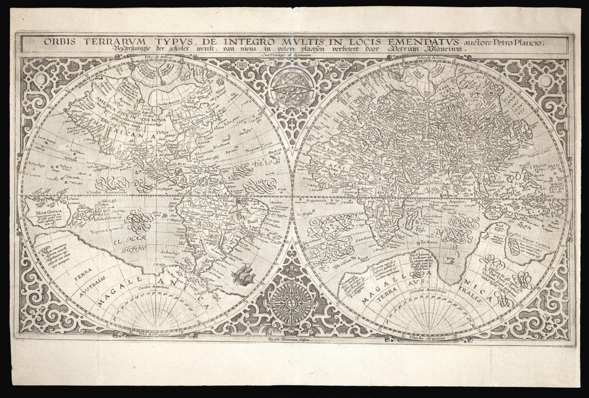
The first map to show Japan as four islands.
Title Orbis Terrarum Typus de Integro Multis in Locis Emendatus auctore Petro Plancio.
Author PLANCIUS, Petrus.
Publication place Amsterdam.
Publication date 1590.
Double-page, double-hemisphere world map, the title in a banner across the top in Latin and in Dutch, text on verso in Dutch.
Notes
A double hemispheric world map after Mercator's world map of 1587. The map was produced for a Dutch bible, as here, the present example with the addition of 'Magallanica' to the large southern continent and its attribution to Plancius.
The map "incorporates the improvements found on the post-1587 world map of Ortelius including a reshaped South America and the insertion of the Solomon Isles. Plancius has introduced yet further changes of his own, based on the latest Portuguese information regarding the far west coast of America and the west coast of Asia. Japan is shown for the first time (not entirely correctly) as one small and three larger islands" (Shirley).
The world is framed in intricate strapwork, with two smaller circles in between holding a compass rose and an armillary sphere. The regular, symmetrical strapwork is linked to continuing ideas about the size and composition of the universe. The use of small bolts and highlights suggest a metallic frame, echoing the armillary sphere and by extension implying the position of the earth as fixed within an limited universe.
Petrus Plancius (1552-1662) was a Flemish cartographer and theologian, best known for his series of biblical and East Indies maps. He was forced to flee to Amsterdam in 1585 after the Spanish invasion of the Low Countries, for fear of persecution as a Protestant minister.
There he began his cartographical career, studying Portuguese charts and becoming friends with the explorer Henry Hudson. He eventually became the first hydrographer for the Dutch East India Company, and produced a series of maps showing routes to the Far East.
Bibliography
Shirley 177; BL 3037.ee.1; Schilder 16; Wagner 163; Wieder vol.2, p.27 and no.7.
Dimensions
350 by 520mm (13.75 by 20.5 inches)Stock number
13894The BADA Standard
- Since 1918, BADA has been the leading association for the antiques and fine art trade
- Members are elected for their knowledge, integrity and quality of stock
- Our clients are protected by BADA’s code of conduct
- Our dealers’ membership is reviewed and renewed annually
- Bada.org is a non-profit site: clients deal directly with members and they pay no hidden fees