Sold
This object is eligible for a Certificate of BADA Provenance
The BADA Standard
- Since 1918, BADA has been the leading association for the antiques and fine art trade
- Members are elected for their knowledge, integrity and quality of stock
- Our clients are protected by BADA’s code of conduct
- Our dealers’ membership is reviewed and renewed annually
- Bada.org is a non-profit site: clients deal directly with members and they pay no hidden fees
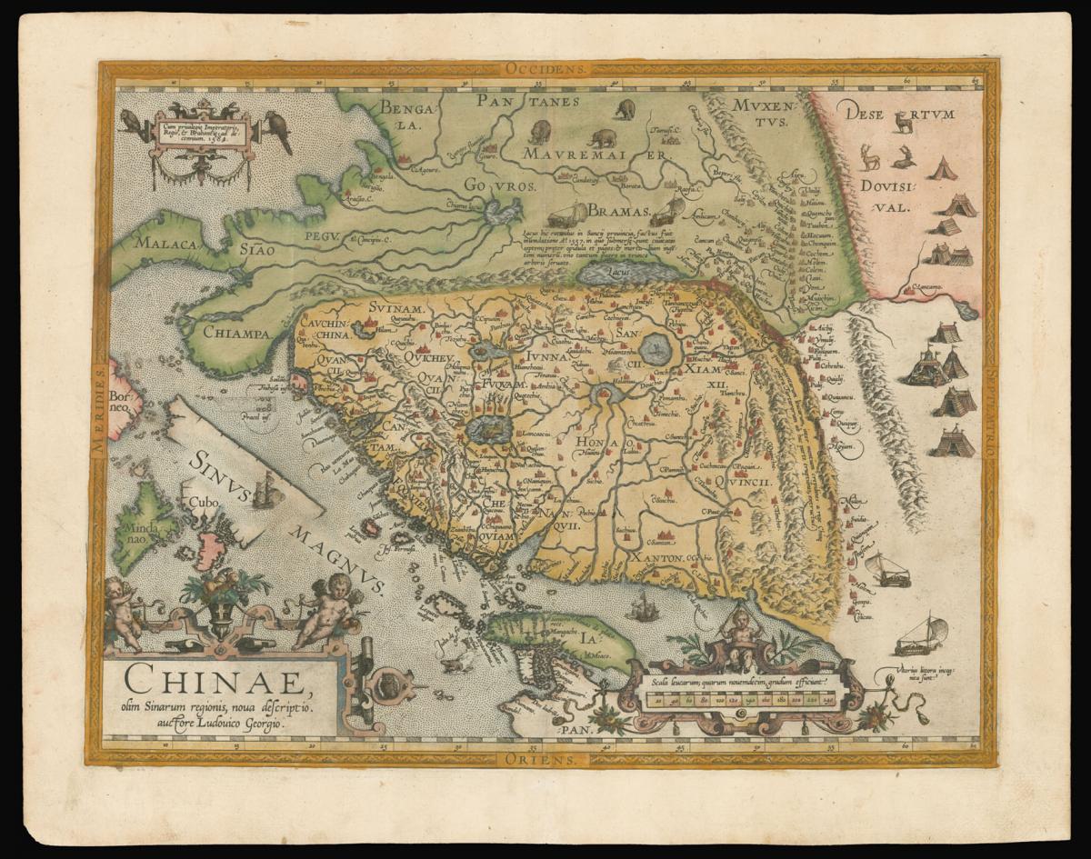
The earliest printed map to focus on China.
Title Chinae olim Sinarum regionis, nova descriptio. Auctore Ludouico Georgio.
Author ORTELIUS, Abraham.
Publisher Plantin Press.
Publication place Antwerp.
Publication date 1584.
Hand-coloured engraved map.
Notes
The earliest printed map to focus on China, and the first to illustrate the Great Wall. It was the first western map of China drawn directly from the findings of the Portuguese mapmaker Luis Jorge de Barbuda, or Ludovicus Georgius. Barbuda was a Jesuit, and he made a manuscript map of China from information on the area gathered by the Jesuit mission. Arias Montanus passed this map on to Ortelius.
The map is oriented to the west. Japan is shown on a curved projection, borrowing from Portuguese sources. Wind wagons are shown in the north, a Chinese invention that also became popular in the Low Countries.
Bibliography
Van der Krogt 8410:31, for atlas see van der Krogt 31:051.
Dimensions
370 by 470mm. (14.5 by 18.5 inches)Stock number
14979The BADA Standard
- Since 1918, BADA has been the leading association for the antiques and fine art trade
- Members are elected for their knowledge, integrity and quality of stock
- Our clients are protected by BADA’s code of conduct
- Our dealers’ membership is reviewed and renewed annually
- Bada.org is a non-profit site: clients deal directly with members and they pay no hidden fees