

Sold
This object is eligible for a Certificate of BADA Provenance
The BADA Standard
- Since 1918, BADA has been the leading association for the antiques and fine art trade
- Members are elected for their knowledge, integrity and quality of stock
- Our clients are protected by BADA’s code of conduct
- Our dealers’ membership is reviewed and renewed annually
- Bada.org is a non-profit site: clients deal directly with members and they pay no hidden fees
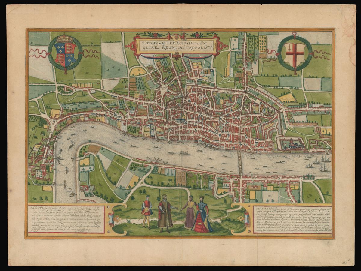
The earliest extant plan of London.
Title Londinium Feracissmi Angliae Regni Metropolis.
Author BRAUN, Georg and HOGENBERG, Franz.
Publication place Cologne.
Publication date 1574.
Double-page engraved view, with fine hand-colour.
Notes
This magnificent plan was first published in Braun and Hogenberg's seminal town book 'Civitates Orbis Terrarum', 1572. London is depicted in birds-eye view from the south looking north. Above the plan is the title in Latin flanked by the royal and the City of London's arms. In the foreground are four figures in traditional Tudor dress, together with two cartouches with text.
The text on the left hand side is a paean to London, which is said to be "famed amongst many peoples for its commerce, adorned with houses and churches, distinguished by fortifications, famed for men of all arts and sciences, and lastly for its wealth in all things"; the text to the right deals with the Hanseatic League, which is praised for its global trade and its "tranquility and peace in public affairs", and names their trading hall in London, known as the Stillard.
Although first published in 1572, the plan is clearly based upon information gathered some years earlier. St Paul's is shown with its spire, which was destroyed in 1561; the cross in St Botolph's Churchyard is shown, although it was destroyed in 1559; and York Place, so named in 1557 is given its old name 'Suffolke Place'. Upon the Thames, the royal barge can be seen, together with numerous ferrymen and sailing vessels.
On the south bank of the river is the new district of Southwark, with its theatres, and bull and bear baiting pits. To the left is Westminster - connected to the City by a single road - with Westminster Abbey clearly visible. To the north of Westminster, cows are depicted grazing in open fields.
The view was most definitely derived from a 15-sheet city plan, of which only three plates have survived. The original plan was probably commissioned by the Hanseatic League, at sometime around 1550, hence the praise heaped upon the League in the text on the plan.
The present example is the fourth state of the view, from the 1574 edition, identifiable by the spelling of Westminster as "West Muster"; the addition of "Cum Privilegio" to the upper border of the right hand title cartouche; and the addition of the Royal Exchange.
Bibliography
Howgego 2; van den Krogt 2433 [London:41.4].
Dimensions
420 by 540mm (16.5 by 21.25 inches).Stock number
14324The BADA Standard
- Since 1918, BADA has been the leading association for the antiques and fine art trade
- Members are elected for their knowledge, integrity and quality of stock
- Our clients are protected by BADA’s code of conduct
- Our dealers’ membership is reviewed and renewed annually
- Bada.org is a non-profit site: clients deal directly with members and they pay no hidden fees


