

Sold
This object is eligible for a Certificate of BADA Provenance
The BADA Standard
- Since 1918, BADA has been the leading association for the antiques and fine art trade
- Members are elected for their knowledge, integrity and quality of stock
- Our clients are protected by BADA’s code of conduct
- Our dealers’ membership is reviewed and renewed annually
- Bada.org is a non-profit site: clients deal directly with members and they pay no hidden fees
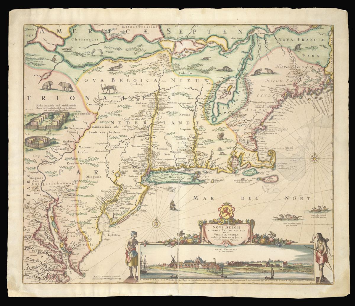
The Dutch and English colonies in Northeast America, with an iconic view of 'New Amsterdam'.
Title Novi Belgii Novaeque Angliae nec non Partis Virginie Tabula multis in locis emendata.
Author VISSCHER, Nicolas.
Publisher Nicholas Joannes Visscher.
Publication place Amsterdam.
Publication date circa 1656.
Double-page engraved map with hand-colour.
Notes
Visscher's second state of Jansson's map of the Dutch and English colonies in North America. The view in the bottom right shows Manhattan roughly twenty-five years after its initial settlement.
This is likely the second published view of Manhattan, the first being that of Joost Hartges in 1651. The authorship of the Visscher view is not known. Some have claimed that it was drawn by the cartographer Augustine Herrman, although Stokes refutes this.
Based on the identification of certain structures in the view, Stokes suggests a probable date for the original drawing of between 1652 and 1653. According to Burden, Jansson's "printed map could have appeared as early as the end of 1653, but no later than 1655".
The main body of the map, depicting the Dutch and English colonies in the Northeast, is derived from a map by Peter Minuit, who is credited with coordinating the purchase of Manhattan from the Lenape for the Dutch. Minuit's map was based on Adriaen Block's chart of 1614, as well as a manuscript map of the area that Adriaen van der Donck took back to Amsterdam in 1649.
One of van der Donck's hopes for his influential manuscript map, and also the goal of Visscher's printed map of the region, had been to entice more Dutch people to emigrate to the colonies. They attempted to achieve this goal by providing an attractive rendition of vast unsettled Dutch lands teeming with game.
However, it seems that life was too comfortable in the Netherlands, since the small Dutch populations that settled New Amsterdam and Fort Orange were soon overwhelmed by an ever-swelling tide of hopeful English emigrants.
Bibliography
Burden 315; Tony Campbell, The Jansson-Visscher Maps of New England, in Tooley, the Mapping of America, page 284
Dimensions
605 by 510mm. (23.75 by 20 inches)Stock number
15627The BADA Standard
- Since 1918, BADA has been the leading association for the antiques and fine art trade
- Members are elected for their knowledge, integrity and quality of stock
- Our clients are protected by BADA’s code of conduct
- Our dealers’ membership is reviewed and renewed annually
- Bada.org is a non-profit site: clients deal directly with members and they pay no hidden fees


