Price
£3000.00This object is eligible for a Certificate of BADA Provenance
The BADA Standard
- Since 1918, BADA has been the leading association for the antiques and fine art trade
- Members are elected for their knowledge, integrity and quality of stock
- Our clients are protected by BADA’s code of conduct
- Our dealers’ membership is reviewed and renewed annually
- Bada.org is a non-profit site: clients deal directly with members and they pay no hidden fees
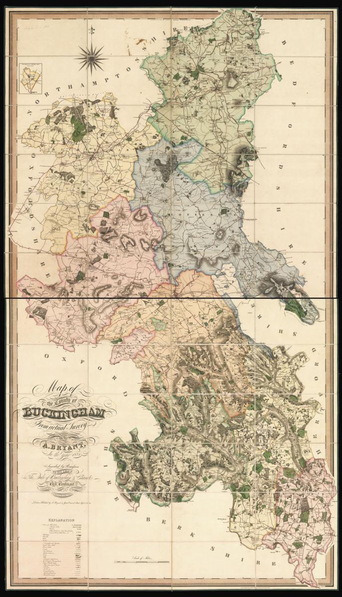
Bryant's large-scale map of Buckinghamshire.
Title Map of the County of Buckingham from an Actual Survey by A. Bryant in the year 1824.
Author BRYANT, Andrew.
Publisher Published By A. Bryant, 27 Gt. Ormond Street.
Publication place London.
Publication date Sept. 1st, 1825.
Large scale engraved map, dissected and mounted on linen, in two sections, fine original full-wash colour, inset map of part of Buckinghamshire found within the borders of Oxfordshire, edged in green silk, housed in original full calf pull-off slipcase, gilt, rubbed and scuffed.
Notes
Bryant's large-scale map of Buckinghamshire, dedicated to Richard Temple-Nugent-Brydges-Chandos-Grenville, 1st Duke of Buckingham and Chandos, who gained his remarkable surname after marrying Lady Anne Brydges, daughter and sole heir of the 3rd Duke of Chandos, adding a further two names to his original three.
Between 1822 and 1835 Andrew Bryant surveyed thirteen English counties, much in the manner of the Greenwood brothers, though without the latters' extreme detail. With their swash lettering, vignette views and meticulous engraving there was a great similarity about their respective output.
Of the six counties covered by both cartographers, in five instances they were both working in the field at the same time, even with the much talked about animosity between the Greenwoods and Bryant, it is most likely that they shared information.
The map, like the Greenwoods', is very detailed, and shows boundaries of the counties, hundreds and parishes, churches and chapels, castles and quarries, farmhouses and gentlemen's seats, heaths and common land, woods, parliamentary representatives, and distances between towns.
The map is on a scale of 1 1/2 inches to the mile. The maps by Bryant are appreciably scarcer than those of the Greenwoods.
Dimensions
2005 by 1150mm. (79 by 45.25 inches)Stock number
12577The BADA Standard
- Since 1918, BADA has been the leading association for the antiques and fine art trade
- Members are elected for their knowledge, integrity and quality of stock
- Our clients are protected by BADA’s code of conduct
- Our dealers’ membership is reviewed and renewed annually
- Bada.org is a non-profit site: clients deal directly with members and they pay no hidden fees