Price
£1200.00This object is eligible for a Certificate of BADA Provenance
The BADA Standard
- Since 1918, BADA has been the leading association for the antiques and fine art trade
- Members are elected for their knowledge, integrity and quality of stock
- Our clients are protected by BADA’s code of conduct
- Our dealers’ membership is reviewed and renewed annually
- Bada.org is a non-profit site: clients deal directly with members and they pay no hidden fees
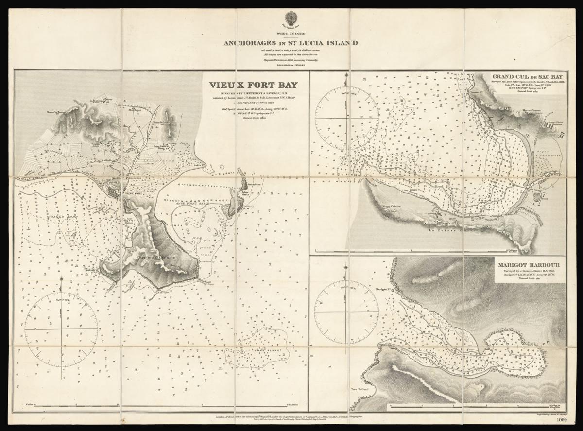
The Bays of St. Lucia in the nineteenth century.
Title Anchorages in St. Lucia Island. Vieux Fort Bay / Grand Cul de Sac Bay / Marigot Harbour.
Author HAVERGAL, Lieutenant A. and PARSONS, J.
Publisher Published at the Hydrographic Office of the Admiralty, Sold by J.D. Potter and E. Stanford.
Publication place London.
Publication date March 1889.
Engraved chart dissected and mounted on linen, three individual maps with coastal profiles on one sheet, numerous soundings and signs of the sea, engraved coat of arms of the Hydrographic Office, brown slipcase with E. Stanford's label pasted on.
Notes
The chart depicts the three principle bays on the island of St Lucia: Vieux Fort Bay; Grand Cul de Sac Bay; and Marigot Harbour. The charts bear soundings, compass roses and other signs of the sea. Vieux Fort Bay contains a great deal of information on the make up of the port and the surrounding countryside.
Since the mid seventeenth century the Caribbean island of St. Lucia has been a consistent controversial issue in the colonial politics England and France. Located between the English headquarters of Barbados and the French equivalent of Martinique St. Lucia was seen as the perfect place to take over the local sugar industry which was established as early as 1763.
The European conflicts of both countries, such as the Seven Years' War, the American Revolutionary War or the French Revolution were hold in St. Lucia as well. Following several changes of sovereignty between the two European countries over the cause of nearly two decades the island was finally ceded to Britain in 1814.
The British Hydrographic Office was founded in 1795 by George III, who appointed Alexander Dalrymple as the first Hydrographer to the Admiralty. The first charts were produced in 1800. Unlike the U. S. Coast Survey the Hydrographic Office was given permission to sell charts to the public and they produced a great number of sea charts covering every corner of the globe.
Most of the Admiralty charts produced by the Hydrographic Office delineated coastline as well as high and low water marks and record depth of water as established by soundings. In addition these charts included information on shoals, reefs, and other navigational hazards that plagued mariners across the world. Thanks to the innovations of Sir Francis Beaufort, who developed the Beaufort Scale of wind strength, the British Hydrographic Office became one of the leading producers of sea charts.
Rare OCLC records two institutional examples: The British Library; and the University of Milwaukee.
Dimensions
500 by 675mm. (19.75 by 26.5 inches)Stock number
12872The BADA Standard
- Since 1918, BADA has been the leading association for the antiques and fine art trade
- Members are elected for their knowledge, integrity and quality of stock
- Our clients are protected by BADA’s code of conduct
- Our dealers’ membership is reviewed and renewed annually
- Bada.org is a non-profit site: clients deal directly with members and they pay no hidden fees