Price
£2500.00This object is eligible for a Certificate of BADA Provenance
The BADA Standard
- Since 1918, BADA has been the leading association for the antiques and fine art trade
- Members are elected for their knowledge, integrity and quality of stock
- Our clients are protected by BADA’s code of conduct
- Our dealers’ membership is reviewed and renewed annually
- Bada.org is a non-profit site: clients deal directly with members and they pay no hidden fees
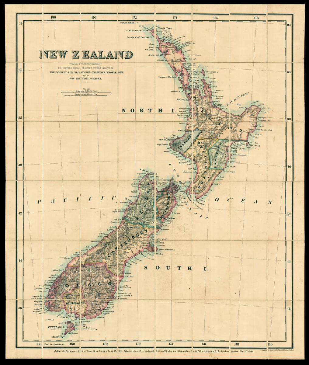
Stanford's large-scale map of New Zealand.
Title New Zealand published under the direction of the Committee of General Literature and Education appointed by the Society for Promoting Christian Knowledge and of the National Society.
Author STANFORD, Edward.
Publisher Edward Stanford.
Publication place London.
Publication date 1866.
Lithographed map, hand-coloured in outline, folding into original blue cloth case with publisher's label.
Notes
A map of New Zealand, divided into colour-coded regions and showing missionary stations. The British government was encouraging migration to New Zealand after establishing sovereignty over the islands in 1840.
They were helped by the discovery of gold, which attracted droves of prospectors in mid-nineteenth century. The impact of the gold boom can be seen in the place names, like Nugget Point.
The present map was commissioned by the Society for the Promotion of Christian Knowledge - the oldest Anglican missionary organisation - and the National Society, part of the Anglican Church, which was set up in 1811 to provide schools for poor children.
Edward Stanford (1827-1904) was a highly successful publisher, known for his accurate maps of London. He began his career working for Trelawny Saunders, an enterprising mapmaker who supplied a daily weather chart for the Great Exhibition.
Stanford started his own business in 1853, was elected a fellow of the Royal Geographical Society the following year and set about expanding the cartographical aspect of the firm.
He bought the stock of the Society for the Diffusion of Useful Knowledge in the early 1850s.
Bibliography
Cartographic Items Maps 213.a.17.
Dimensions
1015 by 835mm (40 by 32.75 inches)Stock number
11553The BADA Standard
- Since 1918, BADA has been the leading association for the antiques and fine art trade
- Members are elected for their knowledge, integrity and quality of stock
- Our clients are protected by BADA’s code of conduct
- Our dealers’ membership is reviewed and renewed annually
- Bada.org is a non-profit site: clients deal directly with members and they pay no hidden fees