Sold
This object is eligible for a Certificate of BADA Provenance
The BADA Standard
- Since 1918, BADA has been the leading association for the antiques and fine art trade
- Members are elected for their knowledge, integrity and quality of stock
- Our clients are protected by BADA’s code of conduct
- Our dealers’ membership is reviewed and renewed annually
- Bada.org is a non-profit site: clients deal directly with members and they pay no hidden fees
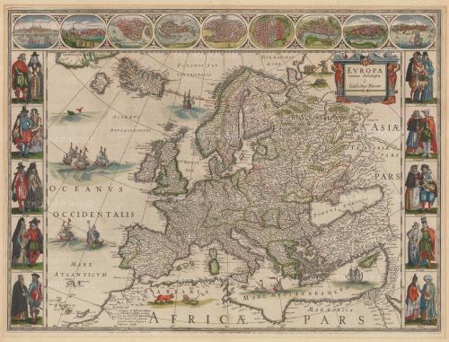
A large, extensive, and richly decorated portolan chart of Europe, North Africa and Western Asia extending from the British Isles to the Red Sea, and including an inset globe showing the Americas. Pen and ink, and wash colour on vellum, heightened in silver and gold. Produced circa 1640, Messina.
The chart has been attributed to Placido Caloiro e Oliva, whose family flourished in Messina between 1621 and 1665. The Oliva cartographic dynasty dominated portolan production in Europe during the sixteenth and early seventeenth centuries. Charts signed by no fewer than 16
different members of the Oliva family are recorded between 1538 and 1673, and individual members apparently worked throughout the Mediterranean world, as their charts originate from Mallorca, Messina, Naples, Livorno, Florence, Venice, Malta, Palermo, and Marseilles. The
exact relationships between the various members are unclear, though similarities in style and content among their works seem to attest to the sharing and transmission of knowledge within the family.
The chart is centred on Sicily and the Mediterranean, with Spain and Portugal, France, Italy and Greece, and includes, in northern Europe: Ireland, England and Wales, with part of Scotland as a separate island; the whole of France, Flanders, and part of Denmark; in western Asia it shows the northern, western and southern coast of the Black Sea, Anatolia, the whole of the eastern Mediterranean coast including a schematic representation of the Calvary surmounted by three crosses in the Holy Land; in northern Africa, part of the Red Sea and the Nile, a rider on a camel, palm trees, and a lion; in the Atlantic Ocean the Canary Islands and the Azores are shown.
At the neck of the chart is an inset globe within a gold border showing the whole world including Europe with part of Scandinavia and Russia, part of Asia until India, as ‘Goa’, the Arabian peninsula, the whole of Africa with Madagascar in red; the Americas, part of North America and Canada, with Florida, Mexico, Nova Spagna, Terranova and Nova Francza labelled, the West Indies including Cuba and Hispaniola, the whole of South America, Magellan’s Strait and ‘Terra di Foggo’.
Framed.
Dimensions
59 x 110 cmStock number
WLD4368Open Monday to Friday from 10:00am - 6pm. Saturday from 10:30am - 5pm. Closed Sundays and Bank Holidays.
The BADA Standard
- Since 1918, BADA has been the leading association for the antiques and fine art trade
- Members are elected for their knowledge, integrity and quality of stock
- Our clients are protected by BADA’s code of conduct
- Our dealers’ membership is reviewed and renewed annually
- Bada.org is a non-profit site: clients deal directly with members and they pay no hidden fees