Price on application
This object is eligible for a Certificate of BADA Provenance
The BADA Standard
- Since 1918, BADA has been the leading association for the antiques and fine art trade
- Members are elected for their knowledge, integrity and quality of stock
- Our clients are protected by BADA’s code of conduct
- Our dealers’ membership is reviewed and renewed annually
- Bada.org is a non-profit site: clients deal directly with members and they pay no hidden fees
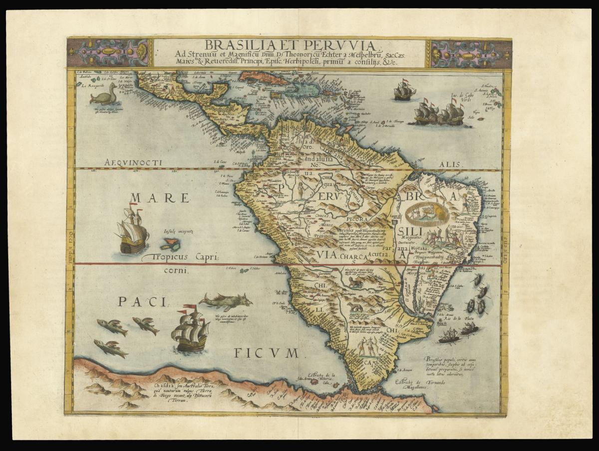
De Jode's map of South America in original colour.
Title Brasilia et Peruvia.
Author JODE, Cornelius de.
Publication place Antwerp.
Publication date 1593.
Double page engraved map, fine original hand colour.
Notes
A fine original colour example of de Jode's second map of South America.
The map shows part of Central America and the whole of South America, including a large landmass representing the Tierra del Fuego merging into Australia. It is one of the earliest maps to show the continent on its own, and the earliest Dutch map of South America.
The Southern American continent's interior is densely detailed with many place names, annotations and images describing the territory, its people, and the flora and the fauna.
Two vignettes show life at a cannibal's campsite, including a human-based dinner, and a battle between indigenous people armed with bows and arrows and explorers armed with rifles. The seas are filled with several vessels, boats, monsters, and more annotations.
The map appeared in the second edition of the de Jodes' atlas 'Speculum orbis terrae'. The 'Speculum' was first published in 1578 by Gerard de Jode (1509-1591) with text by Daniel Cellarius. It was designed to compete with Abraham Ortelius' atlas, 'Theatrum Orbis Terrarum', which had been published eight years earlier.
Ortelius used his influence to disrupt de Jode's application for a royal privilege. By the time this was finally granted, seven years after the publication of the 'Theatrum', Ortelius' work had become so popular that de Jode's atlas did not sell well, despite the accuracy and clarity of his maps.
His son Cornelis (1558-1600) continued his father's publishing business after studying at Douai. He produced an enlarged edition of the 'Speculum' in 1593, which Gerard had been planning before his death.
This map was produced specifically for the second edition. Either Cornelis or Gerard was the first person to make a globe following the geography of Mercator in the southern hemisphere; no copies of it survive to provide evidence.
Although sales of de Jode's work were less than ideal, the atlas was evidently held in high regard, with several contemporaries citing its importance alongside the atlases of Mercator and Ortelius. Few examples of either edition of the 'Speculum' have survived, making the maps within a rarity.
Bibliography
Van der Krogt 9800:32B.
Dimensions
362 by 426mm. (14.25 by 16.75 inches).Stock number
15707The BADA Standard
- Since 1918, BADA has been the leading association for the antiques and fine art trade
- Members are elected for their knowledge, integrity and quality of stock
- Our clients are protected by BADA’s code of conduct
- Our dealers’ membership is reviewed and renewed annually
- Bada.org is a non-profit site: clients deal directly with members and they pay no hidden fees